The Distance Between Degrees of Latitude and Longitude
What is the precise location of Los Angeles? It can be stated in relative terms (about 3,000 miles west of New York, for example), but for a cartographer, pilot, geologist, or geographer, a much more specific measurement is needed. In order to precisely locate any spot in the world, therefore, we use a geographic coordinate system that is measured in degrees of latitude and longitude. This system starts with an imaginary grid of lines that cover the entire planet. Locations are measured based on both X and Y coordinates within the grid. Because the Earth is round, however, the distances between lines on the grid vary.
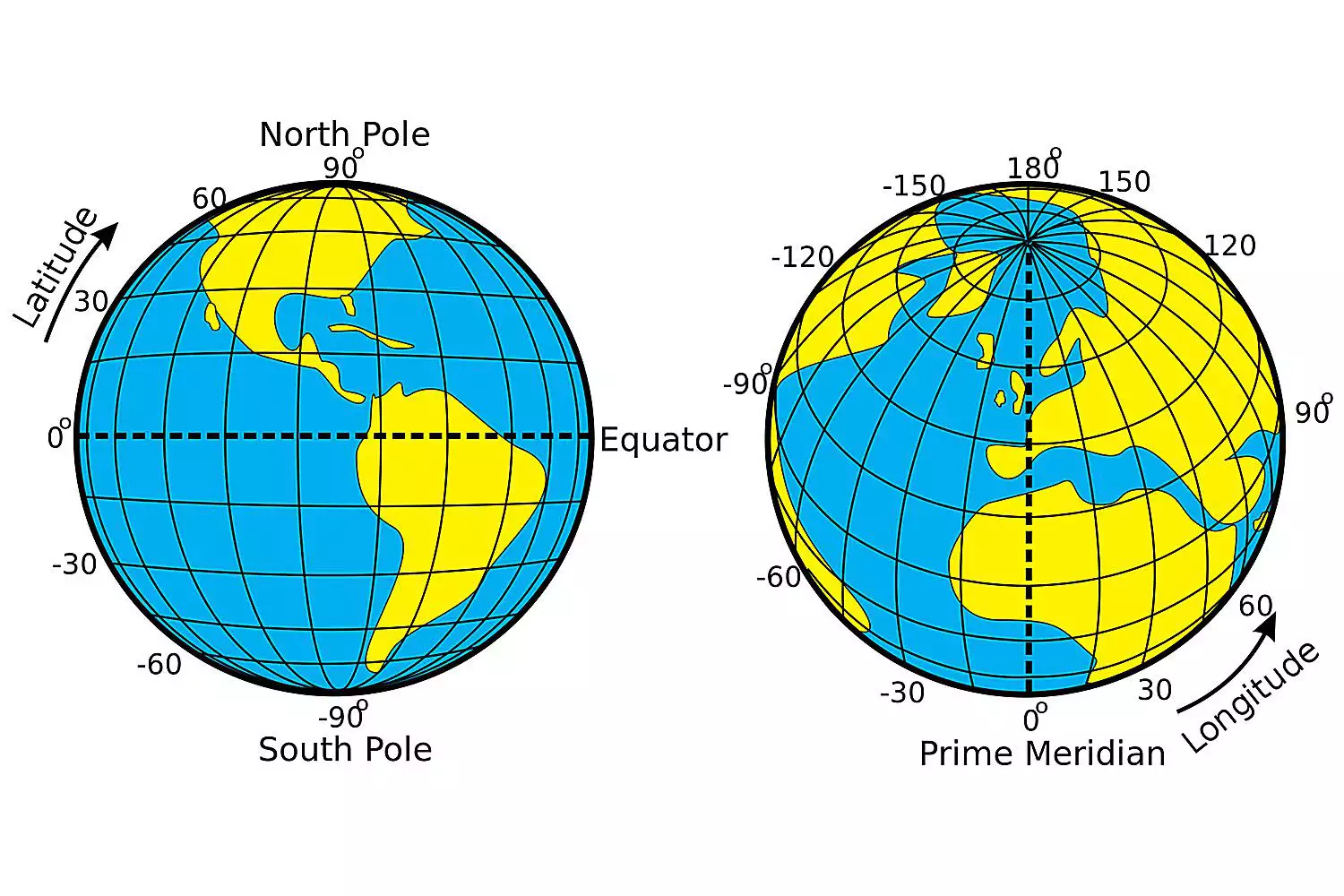
Defining Latitude and Longitude
Longitude is defined as imaginary lines called meridians that run from the north to the south pole. There are a total of 360 meridians. The Prime Meridian runs through the Greenwich Observatory in England, the location agreed upon by a conference in 1884 to be 0 degrees. On the opposite side of the Earth is the international date line at approximately 180 degrees longitude, though the date line does not follow an exact straight line. (This keeps countries from being in different days.) When a person crosses the international date line traveling from west to east, they move up one day. They move back one day when traveling east to west.
Latitude is defined as imaginary lines called parallels because they are parallel to the equator and to one another. The equator, which runs in a circle around the center of the Earth, divides the planet into north and south hemispheres.
Lines of latitude and longitude intersect, creating a grid that allows anyone in any location to pinpoint a geographic location. There are 360 degrees of longitude (because meridians make Great Circles around the globe), and there are 180 degrees of latitude. To further specify exactly where to find anything on Earth, measurements are stated not only in degrees but also in minutes and seconds. Each degree can be broken into 60 minutes, and each minute can be divided into 60 seconds. Any given location can be described in terms of degrees, minutes, and seconds of longitude and latitude.
What Is the Distance Between Degrees of Latitude?
Degrees of latitude are parallel so, for the most part, the distance between each degree remains constant. However, the Earth is slightly elliptical in shape and that creates a small variation between the degrees as we work our way from the equator to the north and south poles.
Each degree of latitude is approximately 69 miles (111 kilometers) apart. At the equator, the distance is 68.703 miles (110.567 kilometers). At the Tropic of Cancer and Tropic of Capricorn (23.5 degrees north and south), the distance is 68.94 miles (110.948 kilometers). At each of the poles, the distance is 69.407 miles (111.699 kilometers).This is rather convenient when you want to know how far it is between each degree, no matter where you are on Earth. All you need to know is that each minute (1/60th of a degree) is approximately one mile.
For example, if we were at 40 degrees north, 100 degrees west, we would be on the Nebraska-Kansas border. If we were to go directly north to 41 degrees north, 100 degrees west, we would have traveled about 69 miles and would now be near Interstate 80.
What is the Distance Between Degrees of Longitude?
Unlike latitude, the distance between degrees of longitude varies greatly depending upon your location on the planet. They are farthest apart at the equator and converge at the poles.
A degree of longitude is widest at the equator with a distance of 69.172 miles (111.321 kilometers). The distance gradually shrinks to zero as they meet at the poles. At 40 degrees north or south, the distance between a degree of longitude is 53 miles (85 kilometers). The line at 40 degrees north runs through the middle of the United States and China, as well as Turkey and Spain. Meanwhile, 40 degrees south is south of Africa, goes through the southern part of Chile and Argentina, and runs almost directly through the center of New Zealand.Calculate the Distance from One Point to Another
What if you are given two coordinates for latitude and longitude and you need to know how far it is between the two locations? You could use what is known as a haversine formula to calculate the distance — but unless you are a whiz at trigonometry, it is not easy. Luckily, in today's digital world, computers can do the math for us.
Most interactive map applications will allow you to input GPS coordinates of latitude and longitude and tell you the distance between the two points. There are a number of latitude/longitude distance calculators available online. The National Hurricane Center has one that is very easy to use.Keep in mind that you can also find the precise latitude and longitude of a location using a map application. In Google Maps, for example, you can simply click on a location and a pop-up window will give latitude and longitude data to a millionth of a degree. Similarly, if you right-click on a location in MapQuest you will get the latitude and longitude data.
Source
"Latitude/Longitude Distance Calculator." National Hurricane Center and Central Pacific Hurricane Center.